
Our Topographic Survey Process
- Every topographic survey begins with a clear understanding of how the data will be used. The survey may support civil engineering design, site planning, grading, stormwater management, utility planning, landscape architecture, permitting, redevelopment, or construction preparation. We confirm the survey limits, required detail level, deliverable format, coordinate needs, and intended users. This helps ensure the final survey provides the information engineers, architects, developers, contractors, municipalities, and property owners need for the next phase of work.
- Before collecting site data, our team establishes control points and benchmarks so elevations and measurements are tied to a consistent reference framework. This step helps improve accuracy and gives designers a dependable basis for grading, drainage, layout, and construction planning. Field planning also accounts for site access, safety, vegetation, structures, utilities, terrain, and any areas that require special attention. For larger or more complex sites, GPS surveys, aerial control surveys, or drone survey support may be incorporated when appropriate.
- Our survey crews collect the physical and natural features needed to represent the site accurately. This may include spot elevations, contours, breaklines, buildings, pavement, curbs, sidewalks, walls, drainage structures, utility features, trees, vegetation, water features, fences, and other improvements. A strong topographic survey captures both natural and manmade conditions. By documenting how the site exists before design begins, we help project teams evaluate land use, access, drainage, earthwork, infrastructure, and construction constraints with better clarity.
- After field collection, survey data is translated into usable mapping and project files. Depending on the scope, deliverables may include CAD base maps, contour mapping, surface models, and existing conditions drawings. Our team reviews the data for completeness, consistency, readable linework, contour accuracy, and practical usability. This QA/QC step helps reduce issues that can arise from missing features, unclear base mapping, or incomplete elevation data.
- The final topographic survey deliverable should help the project team make informed decisions. We prepare mapping that supports grading plans, drainage design, stormwater management, utility planning, site layout, landscape design, permit submittals, and construction preparation. When questions arise during design or review, our team remains available to help clarify survey information. Clean topographic mapping helps reduce redesigns, improves coordination, and gives downstream teams a stronger basis for project decisions.
What Does a Topographic Survey Show?
A topographic survey documents the physical layout and elevation changes of a site. Depending on the scope and project needs, topographic survey services may show:
- Existing grades and spot elevations
- Contour lines and elevation changes
- Breaklines and slope transitions
- Buildings, structures, and major improvements
- Pavement, curbs, sidewalks, driveways, and parking areas
- Walls, fences, drainage paths, and retaining features
- Utility structures and visible utility features
- Trees, vegetation, wooded areas, and landscape features
- Ponds, streams, drainageways, and water features
- Site access, surface features, and major site constraints
- Benchmarks and control points
- CAD base maps or surface models for design
This information helps engineers, landscape architects, architects, contractors, and developers understand how a property functions before design begins. A topographical survey can also help determine whether grading, drainage improvements, utility coordination, or other site adjustments may be needed.
What Impacts Topographic Survey Cost & Timeline?
Topographic survey cost depends on the size, complexity, and intended use of the survey. Key cost and schedule factors include:
- Survey limits and site acreage
- Terrain complexity and elevation changes
- Vegetation density or wooded areas
- Number of site features to document
- Buildings, pavement, utilities, drainage structures, and improvements
- Required contour interval or detail level
- Need for GPS survey, aerial control, or drone survey support
- Deliverable format, CAD requirements, or surface model needs
- Site access and safety conditions
- Deadline tied to design, permitting, bidding, or construction
For clients asking how much a topographic survey costs, the most accurate answer depends on the property and deliverable requirements. Defining the survey limits, intended use, and design needs early helps establish a more predictable scope and timeline.
Civil Design, Landscape & Development Topographic Survey Expertise
Austin Engineering provides topographic surveys for projects where accurate existing conditions data is essential to design and planning.
Civil Engineering & Site Development
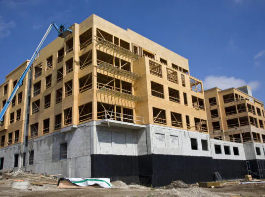
Topographic surveys support grading, drainage, stormwater management, utilities, site access, pavement layout, and infrastructure planning. For projects such as Prairie Lakes Apartments, topographic data can help inform the civil engineering decisions that shape how a site is planned and constructed.
Landscape Architecture & Site Planning

Landscape architects rely on topographic data to understand slopes, vegetation, water movement, grade transitions, and existing site character. This information supports walkways, outdoor spaces, planting areas, accessible routes, drainage solutions, and site planning decisions that respond to the land.
Environmental, Public & Large-Site Planning

Larger sites and public projects often require accurate mapping of natural features, drainage patterns, water movement, and landform constraints. Projects such as the Illinois River Island Ecosystem Restoration and Bloomington Post Office Topo Survey show how existing conditions data can support planning, restoration, infrastructure, and design coordination.
Topographic Survey Services Across Peoria & Davenport
As a topographic survey company with offices in Peoria and Davenport, Austin Engineering supports projects across Illinois and Iowa with consistent standards, local familiarity, and responsive communication.

-
Peoria, Illinois — Corporate Headquarters
311 SW Water Street, Suite 215
Peoria, IL 61602From our Peoria headquarters, Austin Engineering supports topographic surveys across Central Illinois for civil design, drainage, site development, landscape architecture, redevelopment, and public/private project planning. Our experience in the Greater Peoria area helps our team understand the importance of accurate elevation data, existing conditions mapping, and coordinated design support.
-
Davenport, Iowa — Branch Office
220 Emerson Place, Suite 101-A
Davenport, IA 52801Our Davenport office supports topographic survey needs throughout Davenport, the Quad Cities, and surrounding Iowa communities. We assist developers, engineers, architects, municipalities, contractors, and property owners with topographic mapping that supports design, permitting, drainage, and construction preparation.
Why Austin Engineering for Topographic Surveys?
-

Field Data Built for Design Use
Topographic survey deliverables should be usable by the people designing and reviewing the project. Our team prepares CAD-ready mapping, surface information, benchmarks, control data, and readable linework that support practical design decisions.
-

Integrated Survey & Engineering Perspective
Austin Engineering’s land surveying services regularly support civil engineering and landscape architecture work. That integrated perspective helps our survey team understand how topographic data will be used for grading, drainage, utilities, access, site layout, and landscape design.
-

Experienced Survey Crews & Professional Standards
Austin Engineering has provided civil engineering and land surveying services since 1937. With full-service land surveying capabilities, two full-time survey crews, licensed surveyors, and professional involvement with organizations such as the Illinois Professional Land Surveyors Association and the National Society of Professional Surveyors, our team brings experience and accountability to topographic survey work.
-

Practical Coordination From Field to Final Plans
Topographic surveying affects many later project decisions. We coordinate with engineers, architects, developers, contractors, municipalities, and property owners to help reduce redesigns, incomplete base-map issues, and field questions during design or construction.
See What Our Clients Are Saying
“The Austin Engineering team was exceptional to work with, specifically Mike & Jerrod. Despite being during the holiday season, they prioritized my request and completed the survey and relevant documentation timely allowing me to close my property purchase. Their professionalism and expertise is much appreciated.”
“Justin was very helpful, kind and extremely informative! Highly recommend this group if you need any surveyor needs!”
Frequently Asked Questions About Topographic Surveys
A topographic survey documents the physical and elevation-related features of a site, including contours, spot elevations, structures, utilities, vegetation, drainage features, and other existing conditions.
A topographic survey may show contours, spot elevations, breaklines, buildings, pavement, drainage structures, visible utility features, trees, water features, surface improvements, and other site conditions.
You may need a topographic survey before site design, grading, drainage planning, stormwater management, utility design, landscape architecture, permitting, redevelopment, or construction planning.
Topographic survey cost depends on site size, terrain, vegetation, number of features, required detail level, deliverable format, surface modeling needs, and project timeline.
A topographic survey focuses on elevations and existing site features. A boundary survey focuses on legal property lines, corners, and boundary evidence.
Yes. Topographic surveys provide elevation and contour data that helps engineers plan grading, runoff, drainage structures, and stormwater management systems.
How Topographic Surveys Fit Into Your Land Surveying Plan
Topographic surveys are one component of our broader Land Surveying services and often support design, permitting, grading, drainage, construction planning, and project documentation.
- ALTA/NSPS Land Title Surveys: Provide title-driven survey documentation for commercial property transactions, lenders, attorneys, and title companies.
- Property Boundary Surveys: Define property lines, corners, easements, encroachments, and boundary evidence.
- Drone & Aerial Surveys: Collect aerial mapping data for planning, large sites, existing conditions review, and documentation.
- Construction Layout Surveys: Translate approved plans into field layout for buildings, pavement, utilities, and infrastructure.
- FEMA Flood Elevation Surveys: Provide elevation data for floodplain documentation, elevation certificates, and map amendment support.
- Solar Farm Surveys: Support renewable energy projects with survey data for large sites, access, boundaries, and construction coordination.
- Rural Farm Surveys: Help landowners and project teams document rural acreage, access, property limits, and land conditions.
For additional project support, Austin Engineering also provides Civil Engineering and Landscape Architecture services.
Ready to Move Your Survey Forward?
A topographic survey gives your project team the elevation, drainage, and existing conditions data needed to plan with accuracy before permitting, grading, construction, or later project decisions begin. Whether you need elevation data, site features, utility information, or a CAD-ready base map, Austin Engineering can help define the right survey scope for your next step.
Contact our Corporate Headquarters at 311 SW Water Street, Suite 215, Peoria, IL 61602 by calling (309) 315-3643 to discuss your topographic survey needs, timeline, and project goals.