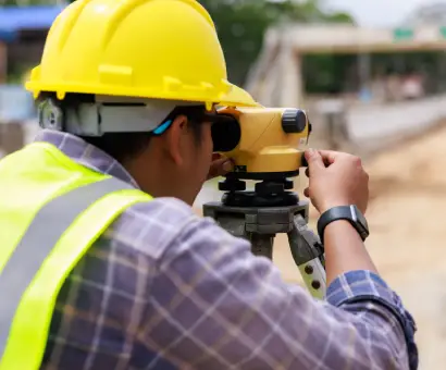
Your Partner for Precision Land Surveying
Accurate Data. Clear Maps. Confident Decisions.
Every successful project rests on the integrity of its survey data. Austin Engineering delivers precise, defensible measurements that serve as the foundation for development, infrastructure, and municipal planning. From initial due diligence to final as-builts, we provide the rigorous field accuracy and documentation that owners, lenders, attorneys, and contractors require to mitigate risk and move forward with confidence.
Why Clients Choose Our Survey Team
-

Defensible Work Product
Boundary decisions are driven by evidence, not assumptions. Our licensed surveyors adhere to strict standards of research, measurement, and analysis, ensuring your plat, legal description, or ALTA survey withstands legal and technical scrutiny.
-

Actionable Clarity
We present complex data in formats that empower decision-making. Our deliverables feature clean layering, readable legends, and precise formatting tailored for engineers, contractors, attorneys, and lenders.
-

Schedules That Hold
We coordinate field work, title review, and drafting from the outset. By sequencing tasks to align with permitting, design deadlines, and closing dates, we prevent bottlenecks before they occur.
-

Professional Integrity
Our team maintains active leadership in ISPLS and ISPLA, while engaging with NSPE, ISPE, and AWWA. This commitment ensures we apply the most current standards and best practices to every project.
Core Surveying Services
We deliver a comprehensive suite of geospatial solutions to support every phase of the project lifecycle. Whether you require ALTA/NSPS land title surveys and boundary retracements for acquisition, topographic mapping for design, or precision construction staking and as-built verification for execution, our team ensures your data is accurate and defensible.
What we do:
When a lender or buyer needs a comprehensive picture of a property, an ALTA survey is the standard. We coordinate with your title company, incorporate recorded documents and exceptions, depict observed evidence of possession, and provide Table A items as requested.
-
Title commitment review
-
Easement mapping
-
Encroachment Identification
-
Utility Verification
-
Tailored Table A options including flood zone classification, height data, and building square footage
Precise boundary determination requires a balance of measurement and professional judgment. We research deeds, recover monuments, and analyze junior/senior rights to resolve discrepancies between record evidence and physical occupation.
-
Deed call evaluation
-
Corner recovery
-
Monumentation
-
Resolution of gaps or overlaps
We capture the reality of your site—not an approximation. Our crews generate clean CAD files and surface models that integrate seamlessly into engineering workflows.
-
Spot elevations, contours, and breaklines for grading design
-
Mapping of Improvements (buildings, pavement, walls)
-
Tree lines and critical features recorded as requested
-
Coordinate systems and benchmarks established for reliable future work
Accurate layout prevents costly rework. We stake control points, building corners, and infrastructure with clarity, communicating directly with superintendents to keep the project moving.
-
Control and baseline establishment
-
Building layout and anchor bolts
-
Curb, gutter, and pavement grades
-
Sanitary, storm, and water stakings (lines, structures, inverts)
-
As-built verification to confirm compliance before cover-up
We prepare subdivision plats and legal descriptions that are correct the first time, preventing future title issues.
-
Subdivision and minor platting support
-
Roadway and right-of-way (ROW) dedications
-
Utility and drainage easement exhibits with bearings and distances
-
Cross-access and shared-parking agreements mapped to the foot
Projects near flood zones require exacting documentation. We verify base flood elevations and support LOMA/LOMR submittals with the necessary survey data.
-
FEMA elevation certificates
-
Finished floor certification
-
Map amendment support
We confirm critical dimensions and elevations to ensure your project meets permitted plans and jurisdiction requirements.
-
Utility structure shots and pipe inverts
-
Paving grades and accessible route verification
-
Detention basin volumes and outlet elevations
-
Deliverables aligned to permit closeout requirements
-
need text
-
need text
-
need text
- Solar Farm Surveying
- Wind Turbine Surveying
Regional Survey Operations
Project success relies on the integrity of its foundation. We combine deep local regulatory insight with multi-state operational reach to deliver rigorous, defensible survey data that withstands scrutiny and accelerates execution.
- Peoria, IL Land Surveying Boundary surveys, ALTA/NSPS surveys, plats, and construction staking coordinated with Peoria-area review standards. Contact Our Peoria Team
- Davenport, IA Land Surveying Riverfront site mapping, topographic surveys, and utility coordination that meet Davenport and Scott County requirements. Contact Our Davenport Team
Processes
- We align on the specific purpose—due diligence, lending, design, or construction—and confirm deliverables and Table A selections. This prevents scope creep and ensures all stakeholders are aligned.
- We gather deeds, plats, and title commitments before boots hit the ground. Strong research reduces wasted field time and ensures no legal rights or encumbrances are overlooked.
- Our crews recover monuments, collect data, and coordinate with utility locators. We verify access protocols in advance to ensure efficient, safe, and accurate on-site execution.
- Licensed surveyors evaluate the evidence to resolve boundaries and prepare maps. We prioritize sound professional judgment to ensure the survey stands up to legal scrutiny.
- Rigorous QA/QC ensures accuracy and readability. We deliver electronic and hard copies promptly, addressing comments quickly to keep your closing or permit application on track.
Ready to Start Surveying for Your Next Project?
Whether you require an ALTA survey for closing, topography for design, or staking for construction, Austin Engineering delivers the accuracy and speed your schedule demands. Tell us your goals and timeline—we’ll scope the right survey, set a clear schedule, and get your project moving.
Start the conversation with our surveying team today.
Frequently Asked questions
Please provide deeds, prior surveys, title commitments, easements, and known site constraints. If utility marking is required, we will coordinate with 811 and discuss private locating needs.
Prior surveys provide context, but site conditions and legal descriptions change. We will evaluate existing documents against current records and observations to advise if a new survey or update is necessary for reliance.
We depict visible or marked utilities. For subsurface infrastructure, we coordinate with 811 and qualified private locators. If precise depth or location is critical, we may recommend Subsurface Utility Engineering (SUE).
Encroachments are clearly depicted on the survey. We can prepare specific exhibits and legal descriptions to support your legal team in resolving agreements or easements.
Expert Insight: Navigating Illinois Survey Standards & ALTA Requirements
In Illinois, commercial transactions often require ALTA/NSPS Land Title Surveys that exceed standard boundary requirements. These surveys are governed by national standards and often supplemented by local mandates regarding flood hazards or zoning. In Illinois, it’s crucial to confirm Table A options, exceptions, and floodplain considerations as early as the kickoff phase.
Another local factor: because many parts of Illinois have complex histories of property subdivision, overlapping parcels, and ambiguous easements, title research often must go beyond default county plat maps—surveyors should examine historical plat books, microfilm, and even original field notes to reconcile discrepancies.
The Austin Advantage:
- Early Definition: We confirm Table A options and exceptions during the kickoff phase to avoid delays.
- Deep Research: In areas with complex subdivision histories, we go beyond county maps—examining historical plat books and original field notes to reconcile discrepancies.
- Proactive Resolution: We flag adverse possession, gaps, or overlaps early, allowing your legal team to address title issues before they threaten the closing.